Bloggfærslur mánaðarins, desember 2019
3.12.2019 | 17:17
A new national maximum temperature record for December
A record breaking "heatwave" passed Iceland last evening and night. It didn't last long but resulted in a new national maximum temperature record for December, 19.7°C at the station Kvísker, situated below the east flank of Iceland's highest mountain, Öræfajökull. The old national record was 18.4°C measured at Sauðanesviti at the north coast on 14 December 2001. This maximum was now exceeded at two other stations besides Kvísker, both in the northern part of the Eastern fjord area - near the easternmost point of Iceland, Bakkafjörður (maximum = 19.0°C) and Seyðisfjörður - Vestdalur (maximum 18.8°C).
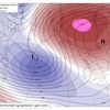
This was due to an northerly excursion of very warm air from the south. According to the analysis of the ecmwf the 500/1000 hPa thickness over eastern Iceland exceeded 5540 meters, might be the highest December value on record for the area - but needs verification. According to the same source the potential temperature at 850 hPa reached 26.3°C at the same time. - Even so, the high temperatures at "ground level" is unusual but probably made possible by the lack of snow in the area and relatively dry ground after a very dry November, generally the driest since 1952 in the Northern part of the country.
Daily (calendar date) maxima were recorded at more than 200 stations, at stations with more than 10 years of observations the records were 178 on the December 2, 111 on December 3 and 20 on December 1.
Previous records for the whole month of December were exceeded or equalled at 53 automatic stations (more than 10 year of observations) and on three manned ones. At Akureyri in the north maximum temperatures have been recorded for 80 years (but temperature has been measured there much longer). During these 80 years the highest maximum was 15.1°C. This was exceeded now as the maximum thermometer this morning (3 December) was at 15.5°C.

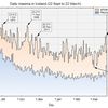
At the automatic stations the temperature is averaged over 2 minutes (thought to be comparable to the response time of a mercury thermometer), every 10-minutes there is a registration of the highest and lowest temperature during the preceding 10-minutes - the highest thus becomes the maximum of these 10-minutes. The figure shows the 10-minute maximum temperatures at the two stations that registered the highest maxima during this event, Kvísker and Bakkagerði during a 36-hour interval from 2 December to noon on 3 December. The rapid rise in temperature at both stations is notable - increasing wind then "exposes" the warm air aloft as it extends down to station level.

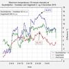
The second figure shows the temperature at Seyðisfjörður - Vestdalur (92 m a.s.l.) and Gagnheiði (949 m a.s.l.), the stations are located close to each other, one in a valley near a narrow fjord in the Eastern fjords area and the other on an exposed, but not steep, mountaintop nearby. The green trace shows the temperature difference between the stations. One might note that the temperature on the mountain is not as variable as down in the valley and the warm air aloft "struggles" to reach the valley bottom - during a short period the temperature on the mountain is higher than in the valley - even the altitude difference is about 850 meters.
 Bloggar | Slóð | Facebook | Athugasemdir (0)
Um bloggið
Iceland Weather blog

Nýjustu færslur
- Unusually high temperatures
- Unusually high sea level pressure
- Sea level pressure: Unusually low in Iceland this winter
- A new national maximum temperature record for December
- A new sea level pressure record for June in Iceland
- An unusually warm April in Iceland
- A new October high pressure record in Iceland
- A new absolute September maximum temperature record in Iceland
 hoskibui
 svatli
Nýjustu myndir
Heimsóknir
Flettingar
- Í dag (4.7.): 0
- Sl. sólarhring:
- Sl. viku: 7
- Frá upphafi: 0
Annað
- Innlit í dag: 0
- Innlit sl. viku: 7
- Gestir í dag: 0
- IP-tölur í dag: 0
Uppfært á 3 mín. fresti.
Skýringar